
Recognized as a global leader in total mooring solutions for the offshore oil & gas and renewable energy sectors, Mooreast has built a strong reputation over more than three decades of delivering high-performance mooring systems and components. As the world's largest drag anchor manufacturer, Mooreast continues to play a critical role in supporting offshore infrastructure projects worldwide.

BeeX partnered with the client by providing:
Ultra-Short Baseline (USBL) systems have long been the industry standard for underwater positioning and tracking. However, performance challenges often arise in shallow-water environments (less than 30 meters deep) and projects involving long layback distances exceeding 100 meters. In these conditions, positioning accuracy can be compromised by signal distortion, multipath interference, and limited receiver slant range.
In addition, USBL operations require extensive setup, calibration procedures, and support from surface vessels, making them both time-consuming and resource-intensive.
To overcome these limitations, BeeX deployed its autonomous underwater drone A.IKANBILIS, during the installation of a six-point Multi-Buoy Mooring system in Thailand. The vehicle performed geo-referenced inspections before, during, and after anchor installation, providing accurate seabed data while significantly streamlining operational workflows.


A.IKANBILIS combines surface Real-Time Kinematic (RTK) positioning, an Inertial Navigation System (INS), multibeam sonar, and high-resolution imaging sensors within a compact autonomous platform.
As the world's smallest autonomous inspection drone capable of performing survey, inspection, and georeferencing in a single deployment, A.IKANBILIS eliminates the need for USBL systems and large launch-and-recovery infrastructures while maintaining high-quality data acquisition standards.
The platform rapidly captures stable multi-sensor datasets, adapts to changing underwater environments in real time, and significantly reduces manpower requirements and operational costs.
During a navigation validation exercise conducted alongside TA Geosolution, coordinates of an underwater shackle were provided as a positioning reference. Using these coordinates, A.IKANBILIS successfully located the target with an error margin of only 0.08 meters, validating the accuracy of its navigation system.

"BeeX's A.IKANBILIS brought a new level of dataset quality and precision to our mooring installation. Without relying on traditional USBL systems, we saved significant time and cost during mobilization while receiving high-quality pre-lay survey data as part of the overall solution. It's a smarter and more efficient way to work underwater."
Nathan Low, Regional Business Development Manager, Mooreast

BeeX's proprietary Sambal Portal enables the real-time processing of navigation, sonar, and optical datasets, eliminating lengthy post-processing workflows and reducing operational uncertainty throughout installation activities.
Stakeholders can immediately cross-reference visual inspection footage with sonar mosaics, providing a comprehensive understanding of seabed conditions and installation progress.
A.IKANBILIS continuously tracks its position and autonomously adjusts its trajectory to compensate for underwater currents. Operators can direct the vehicle to target locations with a single command, eliminating the need for constant manual piloting and reducing operational time by approximately 50%.
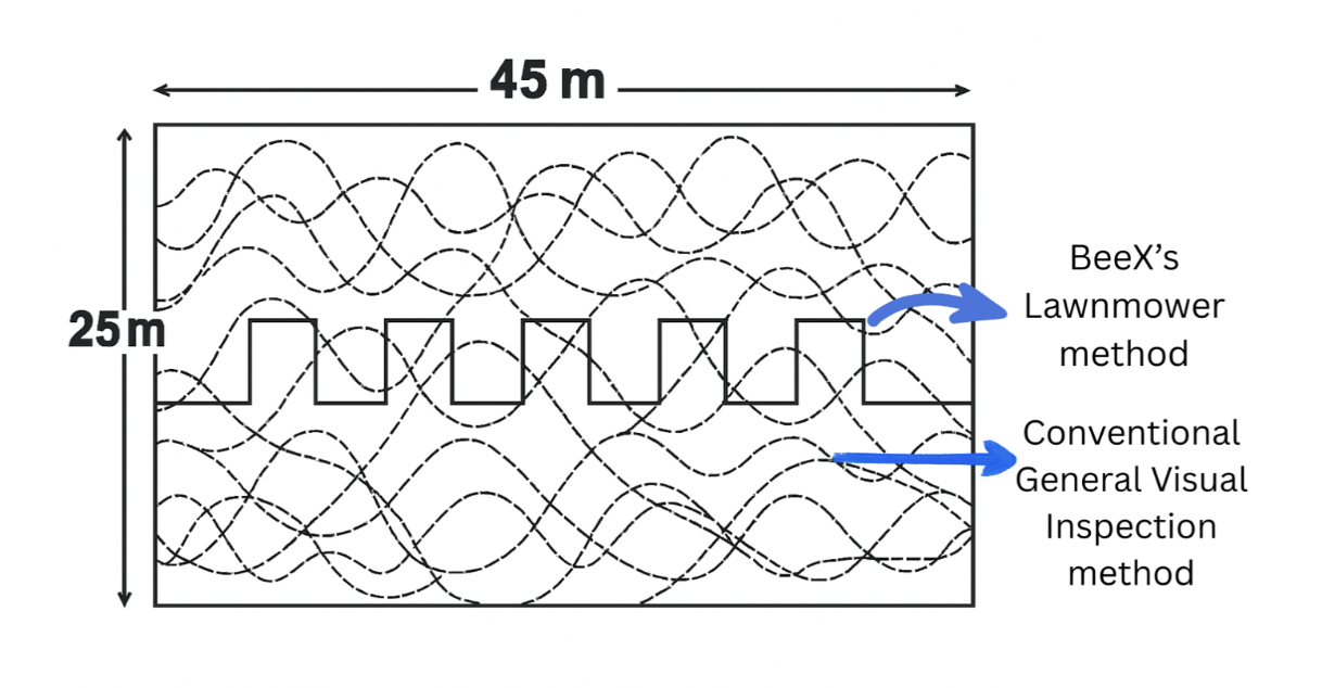
Traditional General Visual Inspection (GVI) methods often rely on pilot-controlled vehicle movements, resulting in irregular survey patterns and inconsistent seabed coverage.
In contrast, A.IKANBILIS utilizes an autonomous "lawnmower" survey pattern, systematically covering the inspection area with uniform track spacing. This approach improves data consistency, increases survey reliability, and enhances operational productivity by at least 50% compared to conventional inspection methods.
The project successfully eliminated the need for USBL systems and their associated calibration requirements, resulting in substantial reductions in equipment rental and mobilization costs.
More than 35% reduction in survey equipment rental costs
0.5-day reduction in vessel mobilization time
Collectively, these efficiencies generated an estimated project cost saving of more than USD 104,000.
The collaboration between Mooreast and BeeX demonstrates how the integration of deep offshore expertise with advanced autonomous technologies can unlock significant operational improvements.
By replacing traditional survey and positioning methods with autonomous underwater systems, Mooreast was able to execute critical mooring installation activities with greater precision, reduced setup time, and richer operational insights.
The project highlights a broader shift toward smarter, faster, and more cost-effective subsea operations—where autonomous technologies are redefining what is possible beneath the surface.
Whether you're in offshore energy, defense, or coastal infrastructure, choosing autonomy
starts with a conversation.
Transforming Underwater
Capabilities at Scale
All Rights Reserved © BeeX Pte. Ltd. 2026